martedì 7 febbraio 2012

Annapurna Himal: Kathmandu - Besisahar - Bhulbhule

(dal mio libro)
 
ANNAPURNA HIMAL
Fra le terre alte nel cuore del gigante himalayano


Leggi le prime pagine
http://ilmiolibro.kataweb.it/schedalibro.asp?id=1023423 

12 Ottobre 2011. Besisahar. Ci si arriva da Kathmandu dopo cinque interminabili ore di viaggio con un piccolo autobus che accoglie, sui suoi scomodi e stretti sedili, 25 persone: 11 italiani, 11 portatori, due guide sherpa ed un autista... ovviamente indispensabile. Noi davanti. I portatori dietro. A bordo, gli zaini ed altro materiale occupano tutto lo spazio che rimane da occupare. Sul tetto hanno trovato posto le grandi sacche dal peso di 18 – 20 chilogrammi l'una. Sono circa 180 chilometri di discreta strada asfaltata e di pista sterrata terribilmente polverosa. Si snoda lungo un percorso fatto di numerosi saliscendi e continue curve in un paesaggio reso a volte gradevole per le verdi colture e le macchie di alberi. Fa molto caldo. Una breve sosta per sgranchire le gambe anchilosate, data l'innaturale posizione, rinfrescare mani e viso ad una fontanella e consumare presso un bhatti o locanda, un dal bhat, il piatto tradizionale della cucina nepalese a base di riso bollito servito con minestra di lenticchie. Con sollievo accolgo il “tutti giù” a Besisahar. Mentre si scaricano a terra le sacche e ciascuno si mette lo zaino in spalla, Khaji Sherpa si reca nel primo di una lunga serie di checkpoint per il dovuto controllo dei trekking permit e per segnalare la nostra presenza. I portatori hanno il loro bel da fare per caricarsi sul dorso le nostre pesanti sacche ed i loro minuscoli zainetti con gli effetti personali. Alcuni tradiscono un'età estremamente giovane, dei ragazzi quasi. Il “mio” si chiama Bishhnu, età 31 anni, occhi neri e carnagione olivastra, come tutti qui del resto. Estremamente riservato, dall'incerto sorriso e di pochissime parole: il suo colloquio in inglese non va al di là di un “good morning” o di un “namaste”, il saluto nepalese.
Ci attendono 238 chilometri di cammino. Un dislivello di 13.680 metri in salita e di 10.890 metri in discesa, metro più metro meno. Massima elevazione il Thorung La, 5416 metri.

12 Ottobre 2011. Besisahar (820 m) - Bhulbhule (840 m) - 9 km. Primo giorno. I primi passi iniziano su un sentierino che scende rapidamente fino a superare, su di un precario ponticello di tronchi di bambù, un fiumiciattolo che si getta nel Marsyangdi Khola. Poi il sentiero si allarga fino a diventare una strada sterrata per un buon tratto, dove è possibile incontrare qualche veicolo a motore. Attorno a noi, un paesaggio agreste dove predominano i terrazzamenti coltivati a riso e la foresta subtropicale e dove scorre il Marsyangdi Khola, qui fiume abbastanza tranquillo e non privo di pericoli durante la stagione monsonica. Superiamo Khudi, antico insediamento Gurung per giungere a Bhulbhule, subito dopo un lungo ponte sospeso alto sul fiume. Cena, pernottamento e prima colazione in lodge. All'esterno fa bella mostra di sé un grande cartello che recita in un inglese, abbastanza corretto: 
 
Benvenuti all'Heaven Guest House & Restaurant
Offriamo:
Ottimo vitto
Servizi igienici puliti
Docce calde 24 ore su 24
Stanze singole, doppie e triple confortevoli
Informazioni sul trekking
Scenari mozzafiato dalla terrazza e dalle camere

Non mi soffermo sulla qualità dei servizi offerti e non mi lamento. La mancanza di comodità a cui siamo abituati noi occidentali, non la considero poi una perdita così grave. E lavarmi sotto la fontana del villaggio mentre altri attendono in silenzio il proprio turno fa parte del gioco. 


ANNAPURNA HIMAL
The Annapurna Circuit and Sanctuary

October 12, 2011. Besisahar. Five hours ride from Kathmandu on a Tata bus. On board, 25 people: 11 Italian trekkers, 11 porters, two Sherpa Guides and a...driver... of course. Our rucksacks and gear fill up every space. No room to move about! On the roof-rack of the bus are the big duffel bags weighing 18 to 20 kilos each. The road winds its way up and down the hills amid cultivated fields and woodland. It is hot. We stop at a bhatti or local inn and have some dal bhat, cooked rice served with lentil-like sauce, a traditional Nepali dish. In Besisahar, the trekking starting point, the duffel bags are unloaded and Khaji Sherpa, the Sirdar of the expedition, pays a visit to the local police check post, the first of many, for registration. The porters load the big bags on their shoulders and are ready to go. My porter, a thirty-one-year-old man named Bishhnu, is a very reserved person: his only Eglish words are “Good Morning” or better, the Nepali word “Namaste” as a greeting.
Ahead of us two hundred and thirty-eight kilometres walk, 13,680 metres to climb up and 10,890 metres down. Maximum elevation: Thorung La (pass) at 5,416 metres.

October 12, 2011. Besisahar (820 m) - Bhulbhule (840 m) - 9 km. Day one. Our first steps follow a path descending steeply to a small narrow river. We cross the bamboo bridge, quite unsteady under our feet. The trail gets larger and larger... it is a dirt road by now and we walk through rice fields and subtropical forests with the Marsyangdi River on our right. We pass Khudi, an old Gurung settlement to reach Bhulbhule, soon after a suspension bridge over the Marsyangdi Khola. On the wall outside the lodge where we stay overnight a sign reads:
Wel Come to
Heaven Guest House & Restaurant
We Serve:
Delicious fresh food.
Clean Toilet & Bathroom.
24 hrs. running Hot Shower.
Single, Double and Tripple rooms with comfortable bed.
Trekking Information.
Breath taking scenery from barandah & room.

Well... not the Queen's English! I will not make any comments on the service or accommodation. Giving up the high standard of comfort and service so typical of our everyday life is not a great loss, after all. And washing your face and brushing your teeth at the communal fountain while the locals quietly wait for their turn to come is quite an experience!

Wednesday, October 12, Kathmandu - Marsyangdi Mandala Hotel. Loading and ready to set out...

Five hours ride from Kathmandu to Besisahar. On board, 25 people: 11 Italian trekkers, 11 porters, two Sherpa guides and... the driver!

Besisahar: punto di partenza per il giro dell'Annapurna.
Besisahar is the starting point for the Annapurna circuit.


Seguiamo il corso del Marsyangdi Khola (fiume) su strada sterrata
Walking on a dirt road along the Marsyangdi Khola (river)


                                                                                                                                                                     (Foto Carlo Zanoni)
Khudi è il primo villaggio Gurung che incontriamo

Khudi is the first Gurung village on the way to Bhulbhule


La grande insegna del nostro alberghetto a Bhulbhule
The big sign outside our lodge in Bhulbhule


                                                                                                                                                                        (Foto Carlo Zanoni)
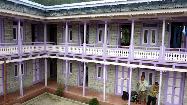
Bhulbhule: l'alberghetto dove alloggiamo per una notte

Bhulbhule: the lodge where we stay overnight


Il fiume Marsyangdi dal ballatoio del Heaven Guest House & Restaurant
The Marsyangdi Khola from the balcony of the Heaven House & Restaurant


Annapurna Himal: Bhulbhule - Chamje


(dal mio libro) 

ANNAPURNA HIMAL
Fra le terre alte nel cuore del gigante himalayano


Leggi le prime pagine 

13 Ottobre 2011. Bhulbhule (840 m) – Chamje (1430 m) – 20 km. Secondo giorno. Tappa lunga, ricca di saliscendi. Io poi, con Lucia ed Armando, siamo andati fuori percorso proprio in vista di Bahundanda, grazioso villaggio alto sulle nostre teste su di un crinale, allungando tempi, distanza e dislivello... o meglio... abbiamo sperimentato un po' di “fuori strada”... ecco tutto! La bassa quota in cui ci muoviamo e l'alta temperatura di una giornata piena di sole mi fanno oltremodo apprezzare una eccezionale spremuta di arance che un solerte nativo prepara davanti alla sua dimora proprio al culmine di una lunga salita. Ottimo il lodge dove trascorreremo la notte anche se l'amico Renato, da buon brontolone, afferma il contrario. Presso l'Hotel Tibet Lhasha per cena posso consumare una zuppa di cipolle, omelette al formaggio, patate bollite ed “apple pie”, torta di mele. C'è la possibilità di lavarsi senza ricorrere alla fontana del villaggio e una toilette decente. La camera, d'angolo, è spaziosa e con ampie finestre. Uno spuntino pomeridiano all'arrivo, a base di salame e formaggio con pane biscotto, sapori rigorosamente italiani che Renato, bontà sua, condivide con me, sono la classica ciliegina sulla torta, mentre discorriamo tranquillamente seduti all'aperto, sul ballatoio.

October 13, 2011. Bhulbhule (840 m) – Chamje (1430 m) – 20 km. Day two. A long journey with uphill and downhill climbs all the time. I get lost just in sight of Bahundanda, a nice village perched high above on a ridge, together with a couple of companions... well... let's say... we only wanted to experiment some “off-the-beaten-track”! It is a hot sunny day, which makes me appreciate a freshly squeezed orange juice made by a vendor just on top of a hill soon after a steep climb. We go past Ghermu, Syange and Jagat and reach Chamje where we stop for the night. The Tibet Lhasha Hotel is a good lodge. For dinner I have onion soup, cheese omelette, boiled potatoes and apple pie. Delicious! The two-bedded room is large with spacious windows and plenty of space to move around in. Last but not least a real clean toilet and bathroom.

Ngadi Bazar
Ngadi Bazar


Giochi di bimbi
 Children playing hopscotch


Bimbi giocano a campana di primo mattino
Children playing hopscotch early in the morning


Thursday, October 13 - Bahundanda is perched on a ridge high above

Lili Bhir: a freshly squeezed orange juice. Delicious!

The huge waterfall near Jagat

Chamje (1430 m): the Tibet Lhasha Hotel where we stay overnight

Chyamche (Chamje), 1430 m, on the way to Tal


Annapurna Himal: Chamje - Timang

(dal mio libro)
ANNAPURNA HIMAL
Fra le terre alte nel cuore del gigante himalayano


 Leggi le prime pagine:


14 Ottobre 2011. Chamje (1430 m) – Timang (2600 m) – 21 km. Terzo giorno. Tempo variabile. Il villaggio di Tal, che si raggiunge dopo una lunga e ripida salita, appare all'improvviso attraverso un orrendo portale in cemento. Al di là di questo, il fiume Marsyangdi forma una grande ansa, le sue acque sono tranquille e scorrono lentamente attraverso il piccolo altopiano. Tal significa “lago” in nepalese ed è proprio questa la visione che si ha di tutta l'area. Il “lago” fu creato da una immensa frana che in tempi lontani riempì ed ostruì una parte del letto del fiume, formando una barriera ed un nuovo e vasto invaso. Vale la pena qui ricordare una leggenda Gurung che così dice: le due montagne che si affacciano sui lati della piccola valle, est ed ovest, sono due divinità che, in continuo contrasto tra di loro, cominciarono a scagliarsi dei grossi massi. Uno di questi causò una grande frana che modificò interamente il paesaggio. A seguito di ciò i sacerdoti Lama del luogo, edificarono un chorten, ben visibile tutt'ora, per placare la loro ira ed impedire così altre disastrose frane. A Tal entriamo nel distretto di Manang. Ci si arriva dopo aver costeggiato su terreno sabbioso la base di una parete rocciosa a picco sull'acqua. Sosta a Dharapani per la pausa pranzo e controllo del “trekking permit” presso la locale stazione dell'ACAP, l'ente parco. Superato l'insediamento umano di Danaque si entra decisamente in una foresta di conifere e ci si inerpica a lungo prima di arrivare ad un crinale dove sorgono due lodge e poche case: Timang. Cena e pernottamento presso l'Hotel Manaslu. Da qui si ha una buona visione del Manaslu (8156 m).

October 14, 2011. Chamje (1430 m) – Timang (2600 m) – 21 km. Day three. Changeable weather. We reach Tal, after a long steep climb. We can clearly see it in the distance through a horrible cement gate, usually announcing a settlement. Beyond the gate a lake and, in the centre of the flat valley, a beautiful village with lots of lodges and houses. The Marsyangdi Khola (river) widens and you have a wonderful scenic view. Tal means “lake” in Nepali and it refers to a gigantic landslide which occurred a long time ago and partially blocked the flow of the river. According to a Gurung legend, the two mountains on both sides of the valley are deities. They were in struggle with one another and started to throw boulders at each other. One of these boulders caused the slide which now occupies part of the area. The local Lamas built a chorten, which is still visible, to appease the gods' anger. You get to the village after an easy walk on the sand at the base of a overhanging rock. In Dharapani,where we have our midday lunch, there is an ACAP (Annapurna Conservation Area Project) post, one of the many you encounter during the trail, to check your trekking permit. Past Danaque, the path grows steeper and steeper in a series of zigzags through a majestic pine forest as far as an open area on a ridge. Two lodges and few houses welcome the visitor. We stay overnight at the Manaslu Hotel.


In vista di Tal, sulle rive del Marsyangdi Khola
Approaching Tal, on the banks of the Marsyangdi Khola


Il fiume Marsyangdi occupa quasi per intero la piana su cui sorge il villaggio di Tal
Tal stands on a flat area where the Marsyangdi Khola flows, surrounded by impressive cliffs


Tal, 1700 m, è un villaggio lindo e pulito immerso in un'oasi di pace
Tal is a quiet, neat and tidy village at 1700 m


Un ponte sospeso lungo 60 m supera il Marsyangdi a quota 1850 m
A 60 metres long suspension bridge crosses the Marsyangdi Khola at 1850 m


In vista di Dharapani al di là del ponte
In view of Dharapani beyond the suspension bridge


Dharapani: uno dei tanti checkpoint, posti di controllo della polizia


Dharapani: one of the many police checkpoints


Danaque: the big prayer wheel and one of the paintings inside a small Buddhist temple


Il nostro lodge a Timal, 2600 m, l'Hotel Manaslu
The Manaslu Hotel in Timal, 2600 m, where we stay overnight


Annapurna Himal: Timang - Pisang

(dal mio libro)
ANNAPURNA HIMAL
Fra le terre alte nel cuore del gigante himalayano


 Leggi le prime pagine:

15 Ottobre 2011. Timang (2600 m) – Lower Pisang (3200 m) – 23 km. Quarto giorno. Il mattino ci dona l'immagine del Manaslu (8156 m). La prima ora di cammino si svolge tra leggeri saliscendi in una grande foresta di pini ed abeti fino al villaggio di Thanchok, splendidamente adagiato su un breve altopiano con campi coltivati. Poche vecchie case raccolte su viuzze lastricate ed inondate di tiepido sole. Nel villaggio successivo, Khoto, abbiamo l'occasione di una breve sosta, giusto il tempo per il controllo dei “trekking permit”. Nell'attesa alcuni bambini – oggi è sabato e non c'è scuola – ci assalgono con le loro richieste. Penna? Caramella? Io mi sogno di estrarre dallo zaino una confezione di caramelle... spariscono tutte in un attimo. Una bambina vuole persino la scatola vuota... forse un souvenir? Superato Khoto, raggiungiamo Chame, grosso centro a 2760 m di quota. Fra i villaggi più importanti, è la sede centrale del Distretto di Manang, una vasta regione, con gli uffici amministrativi, una banca e molti negozi. La mia attenzione viene attratta da un basso, lungo e bianco edificio, una scuola secondaria superiore... classico esempio di deformazione professionale. Un cartello invita gli escursionisti ad acquistare acqua depurata presso un ufficio autorizzato da mettere in borraccia. L'ente parco dell'Annapurna si dà molto da fare per ridurre al minimo l'impatto turistico sull'ambiente anche con questo sistema, proprio per evitare l'inquinamento da bottiglie di plastica. Fra l'altro il sapore è molto buono ed il costo al litro decisamente basso. Il sentiero riprende fra dense e fresche abetaie fino a Bhratang, luogo scelto per il pasto di mezzogiorno. Il riso fritto con verdure è davvero ottimo. Sarà il mio piatto preferito da qui in avanti. Acquisto anche delle mele, piccole e gustose, produzione locale, per dieci rupie l'una (circa dieci centesimi). Sono certamente BIOLOGICHE! La parte terminale della lunga odierna tappa è ancora tra estese conifere con improvvise vedute su altissime pareti di roccia. Cena e pernottamento a Lower (inferiore) Pisang presso l'Hotel Utse. Inizio a prendere il Diamox per prevenire il male acuto di montagna (AMS) che può colpire cervello e polmoni ed in alcuni casi, portare alle estreme conseguenze.


October 15, 2011. Timang (2600 m) – Lower Pisang (3200 m) – 23 km. Day four. The first morning light on Manaslu (8156 m) is a spectacular sight. Now the trail, in a lush pine forest, is all ups and downs as far as Thanchok, a typical Gurung village stretched over a small area of cultivated land. A few houses and lodges are gathered on both sides of its narrow lanes paved with stone plates and flooded by the tepid morning sun. We proceed to Khoto where we have a rest at the local checkpoint. While waiting for the trekking permit to be checked we are surrounded by a crowd of children – no school today, it is Saturday – asking for pens and sweets. I have the bad idea to pull out a packet of sweets... All of them disappear in no time, and so does the empty packet into a young girl's hands! Past Khoto we get to Chame, a big village at an altitude of 2760 m. It is the government centre of the Manang District. Here you can find the government offices, a bank, a post office and lots of lodges and shops for trekkers. The Higher Secondary School is placed in a white building. A sign reading Safe Drinking Water Station, leads you to an authorised sales office providing ozone treated water and owned by the local community. The water tastes good, is cheap and, last but not least, you help the environment by filling your own bottle. The pine forest continues as far as Bhratang. Time for lunch. I have veg fried rice which I find delicious. Well, I will have veg fried rice as my favourite meal for the rest of the trek! I also buy five apples for NPRs50. They are small, savoury and naturally grown without the use of pesticides.
It is four o' clock by my watch when I get to Lower Pisang. Overnight stay at the Utse Hotel. I start taking Diamox to avoid severe AMS (Acute Mountain Sickness), which affects your brain and lungs and can, in extreme cases, be potentially fatal. 

Il Manaslu, 8156 m, dall'hotel dove alloggiamo a Timang
Manaslu, 8156 m, from our hotel in Timang


Khoto: incontri
Encounters with locals in Khoto


L'ingresso trionfale a Chame, centro amministrativo del Distretto di Manang
Entering Chame, the district centre for Manang


Chame: una grande ruota di preghiera ad acqua
Chame: a big water prayer wheel


Chame: muro mani ( delle preghiere)
Chame: Mani (prayer) wall


Chame's impressive Kani is one of the best I have ever seen

Tratto di sentiero che porta a Pisang scavato nella roccia
Now the trail to Pisang is carved out of the canyon walls


Paungda Danda, a sacred rock wall, 4466 m high, emerging from the pine forest

Lower Pisang: l'Hotel Utse, dove alloggiamo
The Utse Hotel in Lower Pisang where we stay overnight


Annapurna Himal: Pisang - Manang

(dal mio libro)
ANNAPURNA HIMAL
Fra le terre alte nel cuore del gigante himalayano 


Leggi le prime pagine:

16 Ottobre 2011. Lower Pisang (3200 m) – Manang (3540 m) – 22 km. Quinto giorno. Giornata ricchissima di emozioni. Da Pisang prendiamo la variante alta che ci permetterà di arrivare a Manang passando per Ghyaru e Ngawal, due insediamenti umani situati ad oltre 3600 metri di quota. Dopo la breve salita per raggiungere Upper (superiore) Pisang, il sentiero si snoda su di un falsopiano fra vecchi pini e vedute sul massiccio degli Annapurna fino ad un antico muro mani. Da qui si stacca una traccia ardita e scoscesa che con numerosi tornanti porta a Ghyaru. Qui la terra è gialliccia per le stoppie e vi è ancora qualcuno che lavora ad affastellare l'orzo appena raccolto. Lo metteranno poi sulle ampie terrazze che sostituiscono i tetti, secondo l'usanza tibetana. Le case sono di pietra, strette le une alle altre, collegate da strette vie per difendersi dai venti e dai rigori invernali. Dal grande chorten bianco scintillante nel sole si domina la vallata sottostante dove scorre il Marsyangdi Khola; sollevando la testa lo sguardo indugia incantato sulla catena degli Annapurna: II (7937 m), IV (7525 m), III (7555 m) e, a seguire, il Gangapurna (7454 m) ed altre cime minori. Dopo la sosta il sentiero continua in quota fino a Ngawal. Il villaggio ha le stesse caratteristiche del precedente e, data l'ora, facciamo sosta per il pranzo. Siamo seduti attorno ad un tavolo nel cortiletto interno di un lodge in pieno sole, per riscaldarci. Si è alzato infatti un forte vento freddo. La sensazione di isolamento è totale. Il sentiero continua a scendere per ampie radure assolate e bruciate dal sole. L'ultima parte della tappa odierna si svolge in una rada pineta. Attraversiamo Munji, lasciamo Bhraka, villaggio fortezza situato su di uno sperone di roccia alla nostra destra e giungiamo a Manang, il villaggio più grande del distretto omonimo.

October 16, 2011. Lower Pisang (3200 m) – Manang (3540 m) – 22 km. Day five. A glorious day today! From Lower Pisang we take the high route which will lead us to Manang via Ghyaru and Ngawal, two settlements located at an altitude of more than 3600 metres. After a short steep climb to Upper Pisang, the trail winds up and down on apparently flat ground through an old pine forest and shrubs as far as an ancient mani (prayer) wall. From this point we take the path to our right, cross a suspension bridge and start climbing up and up in a number of serpentines. We reach Ghyaru, a village where the roofs of the houses are flat, in Tibetan style. They have stone walls and are all clustered around the narrow lanes to protect the villagers from the wind and the freezing cold during the winter months. From the white chorten (Buddhist temple), shining in the morning sun, you can have an overall view of the Marsyangdi Khola down below in the valley floor. You raise your eyes high above and are impressed with the awe-inspiring magnificence of the mountain scenery: Annapurna II (7937 m), Annapurna IV (7525 m), Annapurna III (7555 m) and Gangapurna (7454 m), all of them on parade. The trail continues at high altitude as far as Ngawal, another village in Tibetan style. We stop for lunch: nobody around apart from us. A cold wind is blowing. I feel a deep sense of solitude and isolation. Now the trail goes down through wide open areas of yellow grass burnt by the sun and sparse trees and bushes. We go past Munji, leave Bhraka, a village-fortress perched on a rocky ridge, to our right and get to Manang, the biggest village in the district with the same name. Overnight stay at the Marsyangdi Hotel.


Annapurna II - 7937 m - da Pisang
Annapurna II - 7937 m - from Upper Pisang


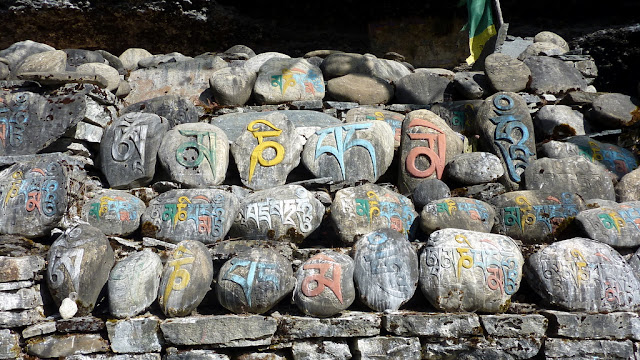
"Mani (prayer) wall" with details of  Buddhist mantras

Sunday, October 16 - Ghyaru 3670 m

Ghyaru, 3670 m - muro mani (delle preghiere)
Ghyaru, 3670 m - mani (prayer) wall


Leontopodium himalayanum (stella alpina himalayana))
Leontopodium Himalayanum (Himalayan edelweiss)


Sunday, October 16 - Ngawal 3657 m

Ngawal 3650 m - Mani (prayer) wall

Ngawal: le case sono di pietra e fango e con il tetto piatto, in stile tibetano
Ngawal: the houses have stone and mud walls and flat roofs, in Tibetan style


Bhraka, a village-fortress at 3360 m

Il grande arco che indica l'accesso a Manang
Manang: the welcome gate