La "Via Segreta" è una lunga ed impegnativa traversata glaciale d'alta quota. Una via prettamente alpinistica che richiede la conoscenza delle tecniche di progressione su ghiaccio, l'uso dei nodi e la discesa in corda doppia. Unisce il campo base del Makalu a quota 4800 metri, nella regione dell'Arun-Barun, con Chukhung a quota 4850 metri, nell'Alto Khumbu, ai piedi dell'Everest. Secondo una antichissima leggenda, è una via percorsa solo dagli dei. Si tratta di superare tre alti passi: lo Sherpani-la (6110 m), il West Col (6135 m) e l'Amphu Lapcha (5800 m), il più difficile e pericoloso. La durata della traversata è di sette giorni.
The "Secret Route" is a long demanding crossing at a high altitude mainly on ice. This alpine route links Makalu Hillary Base Camp (4795 m) in the Arun-Barun area to Chukhung, a village at 4850 m in Solu Khumbu, at the foot of Mt Everest. According to tradition the route is known to gods and legendary figures only. You have to cross three high passes: Sherpani-la (6110 m), West Col (6135 m) and Amphu Lapcha (5800 m), this one being the most difficult and dangerous of them all. It takes seven days.

The "Secret Route" is a long demanding crossing at a high altitude mainly on ice. This alpine route links Makalu Hillary Base Camp (4795 m) in the Arun-Barun area to Chukhung, a village at 4850 m in Solu Khumbu, at the foot of Mt Everest. According to tradition the route is known to gods and legendary figures only. You have to cross three high passes: Sherpani-la (6110 m), West Col (6135 m) and Amphu Lapcha (5800 m), this one being the most difficult and dangerous of them all. It takes seven days.
(da "Ho visto le montagne toccare il cielo" )

Leggi le prime pagine
 |
Makalu Campo Base 4795 m. La parete sud ci sovrasta con i suoi 8463 metri!
Makalu Hillary Base Camp 4795 m. Dwarfed by the south face 8463 m high!
|
 |
1° Campo Alto - 5200 m
High Camp I - 5200 m |
 |
Verso il 2° Campo Alto - Lhotse ed Everest sullo sfondo
On our way to High Camp II with Lhotse and Everest in the background |
 |
Verso il 2° Campo Alto - Makalu 8463 m parete ovest
On the way to High Camp II with the view of Makalu (8463 m) west face |
 |
| 2° Campo Alto 5700 m High Camp II - 5700 m |
 |
Verso lo Sherpani-la
Heading for Sherpani-la |
 |
Sherpani-la 6110 m - parete est
Sherpani-la 6110 m - climbing up the east face |
 |
Sull'esile cresta dello Sherpani-la
Sherpani-la: the ridge |
 |
Sherpani-la 6110 m - parete ovest
Sherpani-la 6110 m - down the west face |
 |
| Il grande plateau ghiacciato di 4 km che conduce al West Col. Quota oltre 6000 metri. Crossing the 4 km long plateau to the West Col at an altitude of over 6000 m. |
 |
| Verso il West Col To the West Col |
 |
| West Col 6135 m - il campo West Col 6135 m - the Camp |
 |
| Una sottile lama di roccia e ghiaccio delimita il West Col - 6135 m West Col 6135 m: a narrow edge of rock and ice! |
 |
| Circa 150 metri separano la selletta del West Col dal ghiacciaio dell'Hongku About 150 metres separate the Hongku Glacier from the West Col above |
 |
| Il tormentato ghiacciaio dell'Hongku The crevassed Hongku Glacier |
 |
| Campo Baruntse 5500 m Baruntse Camp 5500 m |
 |
| Delphinium Glacialis - siamo a quota 5500 metri! Delphinium Glacialis 5500 m high! |
 |
| Campo Amphu Lapcha 5500 m Amphu Lapcha Camp 5500 m |
 |
| Colazione al Campo Amphu Lapcha Amphu Lapcha Camp: morning tea! |
 |
| Amphu Lapcha. Primi risalti di ghiaccio Amphu Lapcha: first ice wall |
 |
| Amphu Lapcha: in attesa alla prima corda fissa Amphu Lapcha: first fixed rope and waiting for our turn to climb |
 |
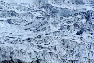
| Mare di ghiaccio: masse informi schiacciate le une sulle altre in precaria posizione Ice, ice everywhere like waves at sea |
 |
| Seracchi e pendii ghiacciati alquanto sostenuti conducono ai 5800 metri dell'Amphu Lapcha Seracs and steep slopes heading for Amphu Lapcha 5800 m |
 |
| Amphu Lapcha: sopra di noi solo il cielo azzurro Amphu Lapcha: only the blue sky above! |
 |
| Amphu Lapcha 5800 m: la cresta sommitale Amphu Lapcha 5800 m: summit ridge |
 |
| La parete sud del Lhotse e, in secondo piano, la cuspide dell'Everest View from Amphu Lapcha: Lhotse south face and Mt Everest summit in background |
 |
| Amphu Lapcha: appena sotto la cresta sommitale Amphu Lapcha: just below the summit ridge |
 |
| Amphu Lapcha: prima calata lungo la parete nord Amphu Lapcha: abseiling down the north face |
 |
| La parete nord dell'Amphu Lapcha Amphu Lapcha north face |
 |
| Amphu Lapcha: la parete nord con la via di discesa. Un salto di 500 metri. Amphu Lapcha north face with descent: a jump of over 500 metres! |
 |
| Verso Chukhung: il lago Imja Tso On the way to Chukhung: Imja Tso (lake) |
 |
| Verso Chukhung: Island Peak 6189 m On the way to Chukhung: Island Peak 6189 m |
 |
| Verso Chukhung: Nuptse-Lhotse, parete sud, al tramonto On the way to Chukhung: Nuptse-Lhotse south face at sunset |
 |
| Chukhung: appena svegli ... dopo molte notti in tenda con temperature abbondantemente sotto lo zero ... è un sottile piacere ... Chukhung Lodge: early in the morning. After so many nights in a tent with temperatures well below zero ... a real pleasure! |
 |
| Chukhung: il cortiletto interno del lodge nel primo mattino Chukhung Lodge: the court early in the morning |
 |
| Chukhung è un pugno di case a 4850 metri. La vista spazia sulla parete sud del Nuptse-Lhotse. Chukhung is a handful of houses 4850 m high with the Nuptse-Lhotse south face in background. |
 |
| Il "Chukhung Resort & Restaurant". Sullo sfondo la mole dell'Ama Dablam 6800 m "Chukhung Resort & Restaurant". Ama Dablam 6800 m in background |